We didn't get up too early. Well, I thought maybe a bit too early, but I was trying to be a better morning person so I didn't grumble too much at the time Ambrose declared for the alarm to go off. Not that the alarm woke him. Both of our options for alarms while backpacking are quiet beepers that don't repeat if you just let them go. We've settled on using the altimeter instead of the camera because it's slightly louder.
 |
| Goodbye horse camp! |
I may have been a little bit slow getting ready. I was sore, as if I had done a lot of work the previous day and hadn't had the requisite twenty hours of sleep to recover. At any rate, Ambrose was ready to go before I was and he started off ahead of me. I knew I could catch him, because our first segment for the morning was another 400 feet up.
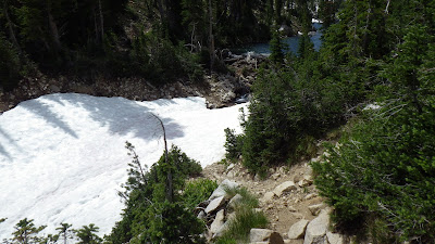
 |
| A little climbing to start the morning. |
I caught him faster than I expected to. He hikes slower than I do, but as I walked up on him, I noticed that his pace was very steady. From what I could see, he was walking at the exact same cadence going uphill as he did on flats, and I think that's a good thing for him to be doing.
 |
| The sun shining on the opposite wall of the canyon. |
 |
| Wispy clouds painting the sky. |
It was less than half an hour's hike for me to reach the our first river crossing of the morning. We took our boots off and got it over with. It's harder to cross those freezing cold streams in the morning than in the afternoon. Especially if there's no sun to recover in. I managed to find a patch of sun, but that didn't stop my feet from burning with cold as I got them dried off and back in my boots.
 |
| Still plenty of snow melt streams flowing here, even in July. |
 |
| There's even still snow! |
 |
| Queens River crossing 1 of 2 for the day. |
We stuck together after that crossing because we were coming up on what would be new trail, first for Ambrose and then for both of us. I had explored a little ways up the trail towards Benedict Creek last year when we initially planned to hike up to Everly Lake, but not very far. We walked through a wooded area, staying near the Queens River, and then the trail turned again for another crossing.
 |
| Another destroyed sign. |
 |
| Ambrose grabbed the camera :) |
We were able to do that one with boots on, thank goodness, and then we stepped onto the section of the trail that was completely new to both of us. The first parts were a little bit steep, switchbacking up and staying near the river. I stayed behind Ambrose and exercised patience at his pace, which was easy because every step seemed to open up a new vista: the brilliant green grasses punctuated by white boulders, all surrounded by high walls of rock glistening with snow melt; the looming bulk of Mount Everly and its companion peak, still harboring large chunks of snow; wet meadows traced by myriad streams all sparkling in the early morning light.
 |
| Mount Everly looming overhead. |
 |
| Queens River crossing 2 of 2 for the day. |
A small lake presented our first snow traversal problem of the day. The trail clearly went under the snow and the snow clearly went over the water. Ambrose led the way up and over the snow off trail so that we wouldn't have to kick step our way across with the consequences of a slip being a dunk in snow melt water.
 |
| A little more climbing. |
 |
| Some boggy meadows. |
After a nice flat section of boggy meadows, the trail began to climb up to a pass that actually had the elevation marked on our maps. I gave in to my desire to move and went ahead of Ambrose, keeping him in sight by stopping frequently. We switchbacked through some trees and then I had to slow down a bit in a rocky section before we reached the top.
 |
| Looking up to Everly's smaller neighbor. |
 |
| Not wise to follow the trail over that snow above the water. |
 |
| Heading up to the pass. |
We took a break there. I stayed at the highest point on the trail and Ambrose went down a bit out of the wind. I wanted to set my altimeter so I had to remain at the known elevation for a prolonged period of time so the instrument would settle. I ate some Reeses spread and put my sour gummy worms my pack's side pocket so I could reach them as I hiked.
 |
| Ambrose coming up to the pass. |
 |
| A fine cornice up on Everly. |
Then we had to go down, spilling most of the elevation we'd gained going up to the pass. To me, the act of "spilling" elevation is always a negative. It's not just going downhill, but going downhill when you just went uphill and will have to go uphill again soon. Downhill is great, but not when I'm going to have to go right back up again.
 |
| Little streams and spilling elevation. |
After getting over a particularly sticky downed tree, we caught sight of an elk ahead, then another and another. I couldn't get my camera up and zoomed in time to get a good picture of the number we saw, but we think there were between 6 and 12 of them, thundering across the trail ahead of us and around a corner where I couldn't see them anymore. I could smell where they crossed the trail though.
 |
| Parts of elk! |
 |
| A freshly downed tree. |
And then we came to the trail junction. One way led to Benedict Creek, and also the Idaho Centennial Trail, where I'll be hiking in August. Another way led up to Everly Lake, and the way we came was the Queens River Trail. We headed for Everly, and found the trail quickly going from damp to wet.
 |
| We're heading to Everly Lake from Queens River - but I'll be seeing Benedict Creek later. |
Now, Ambrose was a bit worried that we wouldn't be able to make it to the lake, because the trail might be snowed in or otherwise impassable. I was certain that we were going to make it. Even when we completely lost the trail in sinking boggy ground and piles of snow, I had confidence.
 |
| Ambrose found a little eggshell. |
Ambrose found the trail, and I confirmed that I agreed it was the trail he had found. Then we began the steepest part of our day. We made our way up through forest, splitting up to verify the direction of the trail a few times and navigating around random piles of snow. I was forging ahead again, and at one point I held out some gummy worms as an incentive for Ambrose to catch up to me.
I'm not sure how much he appreciated that.
 |
| Finding the trail amid snow piles. |
 |
| Looking back down the stream from Everly's outlet. |
The trail took a break from switchbacking when it ran into the outlet stream from Lake Everly. Far below the trail, the water flowed, hidden by a snow bridge. The water had carved the stone into a deep canyon, and the trail followed it just about straight up for a time.
 |
| Snow bridge over the outlet, looking up toward Lake Everly. |
The switchbacks started up again, and I was hoping we wouldn't run into any scary snow traverses. We were getting close to the highest we would get on the trail, and I could feel the icy wind blowing, cooled by the snow it had flowed over.
Every time we came to a snow covered section of trail, I took some time to evaluate it. I looked to see whether the snow covered the whole of the trail. I checked what was on the downside of the trail - a steep fall or flat ground? I looked for a safe route across and made my determination before Ambrose caught up to me.
 |
| Looking back down over the valley, including snow on the switchbacks below. |
We climbed higher and higher, cutting one small switchback because I judged the snow to be the more dangerous path. And then the trail rejoined following the outlet, still from high above. The trail rolled now, going up and down, and then trending down. I caught sight of the lake and began to wonder how we were going to get across the snow bridge once we reached the outlet.
 |
| A nice little log challenge across the trail. |
 |
| Getting up to the top of this pass. |
When we got closer to where the trail crossed the outlet, I could see that the snow bridge left it exposed, but snow completely blocked our route to the trail. I made Ambrose go first over a high fallen tree to come around to the trail.
 |
| Snow bridge over the mouth of the outlet. |
 |
| Not an easy log to cross off trail. |
We were able to walk across the outlet without taking our boots off, and then we climbed up and saw the lake from a vantage point just above it. Near the outlet, the water was a clear turquoise and the lake itself was narrow. As we walked on, the lake widened and rounded, and we were far enough away to see Mount Everly rising over the lake.
 |
| Avoiding the snow while crossing the outlet. |
 |
| If you fall crossing that stream, pretty much, you're dead under the snow bridge. |
As the trail curved around the lake, we kept an eye out for potential campsite. We came across one that I designated "site A" but kept walking. The site was a bit windy and was almost directly on the trail. It was also well above the lake, so water would have been tricky to access.
The trail stayed a consistent distance above the lake, but on the other side, the land was higher and I thought I saw a trail going up. I pointed it out to Ambrose as a place where there might be a spot to camp. Of course, it could have been rocky and bumpy up there for all I knew, but the trail was suggestive. We didn't walk on much farther, because we ran into another stream and decided to check out the higher ground.
 |
| Lake Everly near the outlet. |
 |
| Lake Everly from farther around. |
A nice flat spot awaited us. We decided to drop packs and eat lunch. And then we explored a bit to see if we could find a better site. I found another little lake and a few spots that were almost good, but for being too tilted. They would do if nothing better offered, but we had a better place, so we ended up setting up camp where we first dropped our packs.
 |
| The camping spot with Mount Everly in the background. The lake is too low to see from this angle. |
And then we relaxed and recovered for the rest of the day, getting water and doing camp chores. I wrote my words and read a lot. I cooked dinner of rice and Spam and we had a generally chill evening.


No comments:
Post a Comment