Showing posts with label Sheep Creek. Show all posts

Wednesday, April 20, 2022

April Exploration

My husband and I took an exploratory drive down the Middlefork Road a couple weeks ago. Typically, in the early season, we'll go out to Sheep Creek to do some training hikes to an unnamed peak that we call by its elevation, 6125. But this is the first year that we've had a vehicle we feel comfortable taking out that way in early April. 

Now, we know the route we typically take to the Queen's River trailhead will still be closed. Even with the early warm weather we've been getting, roads like Swanholm are likely to be snowy, icy, muddy or all three. I still wouldn't anticipate going down those roads much before Memorial Day. But the Middlefork Road is kept open through the winter for the town of Atlanta, so we figured the Subaru could make it. 

And we could always turn back. 

That morning, I had a few chores to take care of before we headed out. A disappointing dentist appointment, and a very quick and easy blood donation. Now, I had thought that I might hike after this, but then the Red Cross folks reminded me that I shouldn't be exerting myself too heavily after donating blood, so when I got home from the donation, I made sure to grab a towel and my bikini in case I could convince Ambrose to stop at a hot springs. 

He was in a VERY big hurry so I ended up leaving the house with neither my phone nor my camera. Therefore, we saw a lot of cool stuff that we usually don't see, and I have no photographic evidence to offer! 

For starters, the water levels around Discovery Park were abysmally low. There were a ton of sandbars showing, and where folks usually paddleboard there looked like hardly enough water to keep someone afloat. Sand Point had absolutely no water in it, with the spout totally dry. Then, we saw a helicopter taking off from the Lucky Peak Helibase as we were driving along 21. I always see the sign for the Helibase, but this was the first time I'd actually seen a copter taking to the air from it. 

As we drove around the Lucky Peak reservoir, I was disappointed to see the low water levels were also on display here. Low water levels will only exacerbate the fire season, and we had a pretty bad one last year. Only a few boats plied the shallow waters on this day, and the floating docks that sprinkle the banks were flat on dirt, well above the water line. 

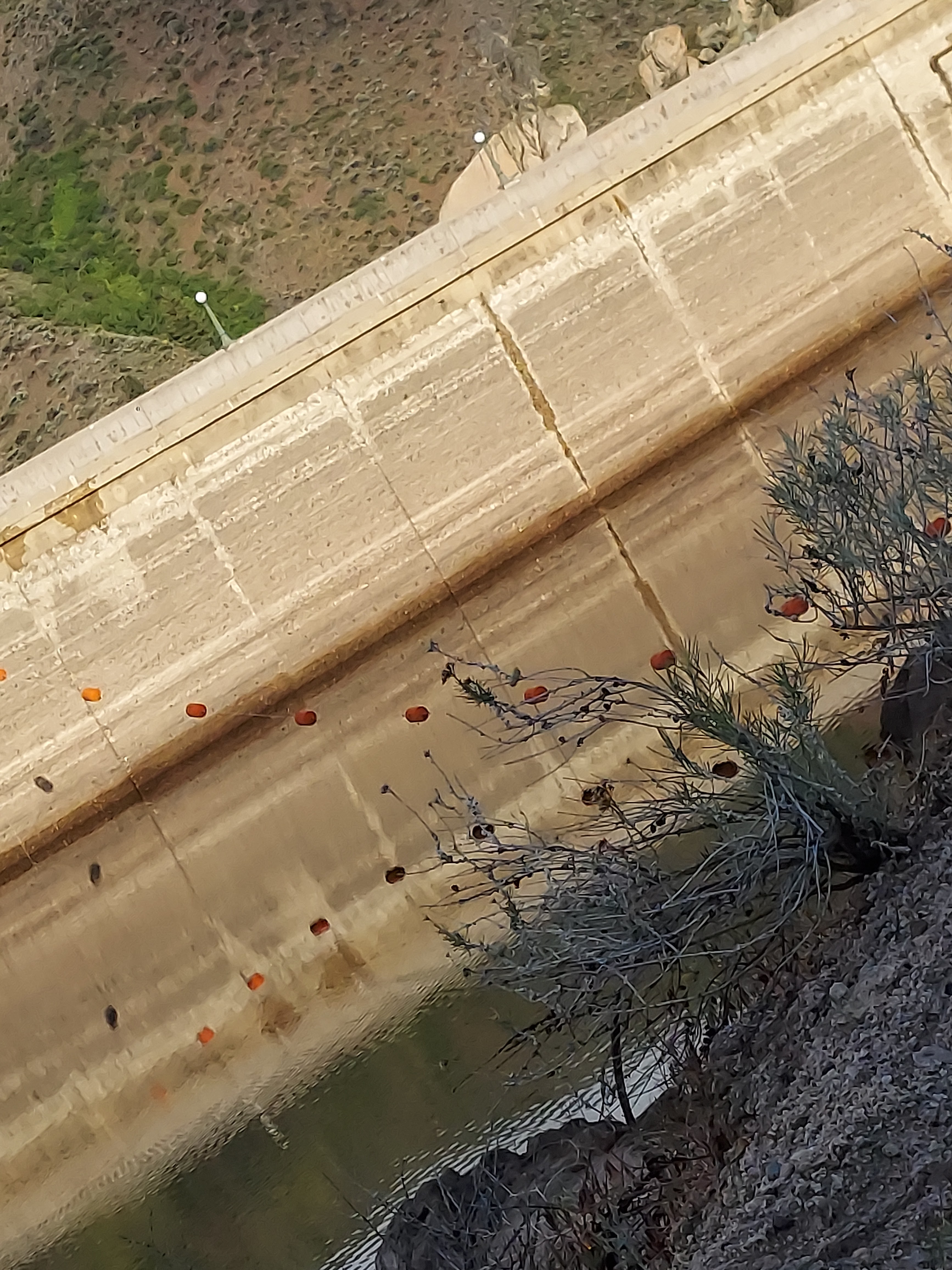
I was hoping that the Arrowrock reservoir would be mostly full. Last year, we never saw any water coming down the spillway next to the dam. This year, I saw a trickle flowing out and sighed with relief. Indeed, when we got to the top of the dam, it was clear that this reservoir was nearly full. Oh, and we finally got caught with another car coming at us driving that very narrow part of road above the dam. I'm always nervous about a car popping up, but it actually went fine. They backed up because they were closer to their end than we were to ours and we got around them on the wider part of the road. 

It lifted my heart to see the water levels at Arrowrock higher than I'd seen them in a few years. There were several boats out on the water, and not a whole lot of traffic on the road. As we drove along, we kept an eye out for trails to try. Near one of the pit toilets, we found one that we'll be trying this weekend. It has no shade and looks like it's just straight up a ridgeline, perfect for training! 

But on this day we drove on. Now that we have a Crosstrek, I no longer dread the speed bumps in Twin Springs. I mean, I get that they need to be fairly aggressive to stop people from driving fast through the resort, but I was always nervous driving the Focus over them, let alone the old Civic. The Crosstrek handles the speed bumps just fine. 

Soon after Twin Springs, we drove by a car sitting at the side of the road, looking abandoned. One of the windows was open and there looked to be some damage. So that's another unusual thing we saw. 

The Sheep Creek trail looked like it would be doable, if not that particular day, then quite soon. There was some snow way up on the ridgeline above Twin Springs, but most of the trail we'd take wouldn't be right on the ridge. So that one should be ready for a mid-May hike, even with the snow we got last week. 

As we drove on, because I had indeed convinced Ambrose that a visit to Loftus Hot Spring was in order, we came across yet another abandoned vehicle. But this one was a bit more spectacular. It had clearly rolled based on the damage, and it had also clearly been there a while, judging by the numerous bullet holes in the side facing the road. The license plate was no more, either fallen off or removed. 

We arrived at Loftus just as another couple was leaving so the timing was just right. I got to enjoy a nice little hot soak, and Ambrose tested out his InReach Mini. I really ought to get mine better set up, but I keep putting it off. Then we headed back. 

Ambrose turned in to get a closer look at the rollover wreck, but I warned him against taking my car tires too close to the piles of broken metal and glass around it. We did get a little closer to it, but not too much. 

On the drive back, a large bird of prey caught my eye. It was practically posing for me atop a large, leafless tree. Of course, of course, that's only going to happen when I don't have a camera! Based on the side and coloration, I think it was a golden eagle. But it sure would have been nice to have a picture to confirm that guess. 

We had a good drive overall. It always makes me feel better to be in the woods, if only for a brief afternoon. 

Wednesday, June 30, 2021

6125 Training Hike

Ambrose and I are trying to get out together almost every weekend in June. The one we aren't going to be our together for is the one where I'm going to volunteer with the Idaho Trails Association for some trail work. Other than that, the plan is to be out every weekend. So, for the first weekend in June, following our inaugural backpack on Memorial Day, the plan was somewhat different. 

I didn't really understand the plan until we went over it together on Thursday evening. And it's a good thing I asked then, because the plan was for us to head out to the trail directly upon my leaving work on Friday evening. I got packed really quick after that on Thursday!

We would drive out to the Sheep Creek trailhead, spend the night, pack up in the morning and go hike 6125 (which is the elevation of a nearby mountain with no other name/designation). It's a great training hike; lots of gain, nice and long. Longer, now, than it used to be since we are using the new official trailhead instead of the old one. 

The drive out was nice and relaxing for me. Ambrose was driving and I was feeling a bit floaty from taking a bit more Aleve than is strictly recommended to treat my PMS. There wasn't a whole lot of traffic, and the road was as good as it ever is. Bumpy, but not frighteningly so. 

We saw jetskis coming into the reservoir from upriver and wondered how far they'd managed to go upriver. Ambrose thought they could have made it to Twin Springs, but I wasn't sure. Watching the water as we drove by, I thought there were some rapids that would have made most jetskiers turn back, but I've never tried to take one through a rapid. 

At the trailhead campsite, about half the sites were taken; the remaining spaces had some cars in them, but no people. So we parked between the two unoccupied cars and claimed that space for ourselves. I got the tent up in short order, though I did have to re-stake it once the wind decided to test my pitch. No rainfly for this night, because it wasn't just warm, it was hot, even at 8 pm with the sun behind the ridgeline. 

It was delightful to sleep under the stars, with just the mesh between us and the sky. And we didn't even need our sleeping quilts it was so warm. We ended up using the blanket we usually use for insulation on the air mattress as a blanket. 

The alarm was set for 5 am, and I actually felt well-rested when it went off. We proceeded with striking camp in harmony. It was like a dance; I'd finish bagging something, Ambrose would bring it to the car, then I'd have the next thing ready for him. We took the tent itself down together, and ate breakfast and took turns with the shovel. 

I tried several times to get a picture of this bedhead and this was the best of the lot.

We were on the trail before 6:15, beating the sun's rise though it was on the way. I had planned on using Gaia GPS to record the hike, but it refused to acquire a signal so I asked Ambrose to drop it in my pack instead, just so we could get going. 

After Ambrose beat me to the car on Memorial Day, I figured he'd be up on me on this hike. That was not the case, even though I was not feeling my best with my period hammering my guts. I pulled well ahead and stayed there. 


With the sun rising behind me, this ridge looked like it had reverse alpenglow.

At the Sheep Creek saddle, I saw a pair of hikers ahead of me, and I totally used them to speed myself along the trail. They kept going along Sheep Creek, beyond my turn off, before I could pass them, but I got close. I was glad they hadn't turned off, because I needed to dig a hole, and I didn't want other people close by. 

I thought for sure Ambrose would pass me while I did that, but he only walked up as I was putting my pack back on. I thought, again, that he'd keep up for a while, but I left him behind again, well before I started the evil traverse. 


If I had been going the same direction, I would have totally caught these two!

From where we cross Sheep Creek up to 6125, there's about 2500 feet of gain. Much of that takes place over about a mile, along a dry, sunny stretch of trail that tends to singletrack and is mostly small rocks, aka ball bearings. It is a rare hike that I do not slip and fall on those rocks - at least on the way down. 

On the way up, I didn't have too much trouble. A few slips, but nothing scary. I just kept going, powering on up even when I very much just wanted to sit down and stop. 

Instead, I skipped my usual rest stop at the Twin Springs couch and recited a litany of things I needed to do at the peak. Take off socks and shoes to shake dust out of socks. Finish the peanut butter chocolate chip cookie I was munching for breakfast. Put on sunscreen and convert pants to shorts and shirt from long to short sleeved. See if I could get the Gaia GPS to work so I could record at least half the hike. 

After the couch, the wind picked up, and I felt much cooler than I had with the rocks beaming the sun into my face. Flowers abounded, with multiple shades of purple along with a few of yellow and a small stand of bright red paintbrushes. I took a moment to enjoy the view down to Twin Springs, but without sitting. Sitting was for people who made the peak!


The sun found me! Way earlier than I would have preferred :(


I always find the view down to Twin Springs enchanting.


These sitting rocks, to me, mark the peak. 

Once I made the peak, I found that my list had acquired a new item. Dig a hole! I was glad that my digestive system was moving along so well, even though digging holes is a time suck. Then I wrapped up the other items on my list - including starting the Gaia GPS track - and started down, expecting to see Ambrose at any moment. 

He wasn't the closest that I've caught him coming back, but he wasn't too far down. I expected him to be an hour or so behind me. Maybe 90 minutes. 

I had a slip-slide heading down to the couch: my body's momentum swung me away from the trail and I had to move my feet quickly as well as lean the other way in order to stabilize. It felt a lot scarier than it sounds to write. Probably because I failed to describe that if I hadn't jerked myself around, then I would have rolled down a steep hill, on rocks, through scratchy bushes. 

I tried to take it slow down the ridge traverse, because those rocks just love to slide. Only one more notable slip made for a pretty good trip down. I do like the Altras for their grippiness on a variety of terrain, even though I really wish they'd make a women's wide. I've hiked this trail enough to know that they handle its ball bearings very well. 


There he is!


A snake!

But not a rattlesnake :)


I was excited to get off the ridge and down to the side stream crossing just before the bridge over Sheep Creek. I took advantage of the stream and dipped my sunhat in to help keep me cool for the end of the hike. Pro tip - rather than let the sun hat's tail get my backpack all wet, I rolled it up and tucked it under my shirt collar. That kept my neck cool and kept the tail wet a lot longer than if it had been exposed. It worked really well until the wind got strong and blew it off my neck - but then the wind was cooling me, so fair trade. 

I passed one pair of hikers heading out as I made my way back to the trailhead, finishing in just under 6 hours. 


My official time back to the car - we started at 6:12 am.

And what, exactly, did I do in 6 hours? Well, the track from the top down gave me a distance of 5.1 miles, so I did 10.2 miles. And, apparently, 2810 feet of descent. I felt like it. 

I moved the car to the shade, changed clothes and tried to stay cool while I waited for Ambrose to show up. 

When the first hour had passed, I was little worried, but not super worried. 

At two hours, I was starting to plan the rescue. Knowing that the total distance was 10 miles, I ended up deciding that I'd give him one mile per hour before doing a rescue. Only partly because I did NOT want to go back out there. 

After the 4th time I moved the car into shade, I could no longer read short stories on my phone. I was worried, thinking what could possibly have happened to him that he ended up so much farther behind me. What if his ankle were twisted or broken? Well, then I'd just have to do the Chamberlain hike with Bill and Mike only. He'd just miss out. 

After 2.5 hours had passed since I got back to the car, but less than 3, I finally caught sight of him coming down the trail. I had been feeling tired and cranky, but he looked a lot worse than I felt, so I went directly into caretaker mode and got him as settled as possible. When he poured potable water on his sweat rag, I went down to the river to get him some river water for cooling purposes instead. We didn't have enough potable water in the car to use it like that. 

Ambrose's official time back - which I only later learned was influenced by not one, but TWO naps on the trail. 

There was pretty much no way Ambrose could have driven home in that state. And, his tiredness was actually a blessing, because he discovered just how relaxing a drive could be when he closes his eyes and doesn't try to backseat drive. I felt quite cheered that he was able to relax while I drove these scary roads. He pretty much only opened his eyes when I talked to him or asked for water. 

Now, if only there was a place to buy slushies on the way home, the day would have been perfect.

Wednesday, June 2, 2021

Car Camping on the Middle Fork

The weekend was supposed to be rainy, and that was actually good news for us. When there's rain in the forecast, it doesn't always come, but it always prevents at least some people from coming out into the woods! 

We didn't have a campsite selected before we set out. The idea was simply to drive along Middle Fork Road until we decided it was time to stop. We weren't going to go all the way to Atlanta, but we were open to exploring past our usual spots. 

The clouds were incredible on the drive out.


I was following our route on Gaia GPS, and I saw a place where there was a spring, near Alexander Flat. The spring wasn't specified as hot, so I figured it probably wasn't, but at the same time, I wanted to check. Loftus hot spring had been, predictably, very occupied, so I was hoping to find another hot spring to take a soak in. 

The water level at Arrowrock Dam is really low for this time of year.

More awesome clouds.

Inaccessible hot spring - and no pool. 

More inaccessible hot springs across the river.

And as we slowed to look for the water, I saw a camping spot. There was another site occupied in the general area, but decently far away, with some trees for concealment. The site was undeveloped, so no pit toilet, but it was also quite pretty, for a car camping spot. We parked and walked around a bit, exploring the area before I put up the tent (Ambrose drove, so I put up the tent). 

A fire ring is a sign of a developed site, though we wouldn't be using it.


Ambrose helped bring things into the tent after I pitched it.

After that, we went looking for the spring, hiking up a bluff to find that it was just a normal, cold spring. Pretty, but nothing to take a dip in. Then we just chilled. I read the entirety of Cougar Dave: Mountain Man of Idaho, 1855-1936, and started on another book while the rain visited us intermittently. It never really stormed, but there were several showers - live versions of one of our favorite YouTube videos - 10 Hours of Rain on a Tent. 

Ambrose looks for the spring.

This is pretty much it.


The next day, we got up in a leisurely fashion and headed home. I was driving, and I decided to pull in at Sheep Creek and take a look at the hot spring there. I've never actually used that hot spring, because every time I go there, there's no pool worth using. Too shallow or too cool for my tastes. 

This year was no exception. 

There was a pool of decent depth, but it was very close to the river and hardly warm to the touch. The higher pool had heat, but no more than two or three inches of water. Ambrose tried to build up the outflow to make it retain more, but we didn't have the tools for the job, and I wanted to get home. 


On the drive out, we had to wait for some guys trying to turn boat trailers around, but they did let us pass once it became clear that we could travel faster than they could. Minorly irritating, but then something really cool happened. As we slowed to allow another driver to pass us by coming the opposite direction at a good passing point, they slowed as well and lowered their window. 

A man leaned out and asked us if we could tell him how to get to a camping spot, how far he should keep driving. I gave him enthusiastic instructions - for an official campsite, I recommended Badger Creek or Willow Creek and for dispersed, drive past the bridge past Twin Springs and pick a spot you like. It was a nice cap to a nice weekend. 


Wednesday, May 26, 2021

Day Hike on Sheep Creek

The week before, I had been sick, so I got to sit by the river and bathe in the sounds of nature while Ambrose went on a day hike (and did all the driving). This week, I had managed to pass my sinus infection on to Ambrose, so it was my turn to do the driving and the hiking while he sat by the river. 

We got up nice and early on Saturday, and managed to leave only a little later than we had the weekend before. We made up a tiny bit of time by skipping the Warm Springs detour and just taking Broadway to 84 to 21 instead. But I wasn't in a hurry, especially once we got onto the dirt portion of the Middle Fork Road. Hurrying on that road is a good way to get in an accident! 

And I didn't really have a set schedule for this hike anyway. Just, get to the trailhead, set Ambrose up on the bank, hike out as far as I wanted, maybe the second crossing, come back and drive home. I guess that's quite a list of steps, but there were no times so I'll call it unscheduled ;)

I got us safely to the trailhead - didn't even scrape on the speed bumps in Twin Springs. The week prior, we'd had the trailhead campground to ourselves, but this week three of the four main spots were occupied. Ambrose kind of wanted to try another spot, but I was driving and I decided we could take the unoccupied spot. After all, there was no indication that the other groups were trying to claim it. 

We parked without complaint, and then I helped Ambrose set up his spot. He tried to take some pictures of me as I hiked off, but there were issues with the camera and none of them came out. 

I felt good as I hiked off with my day pack. I was using my Black Diamond pack, which is my go-to day pack. It's fairly small, so it helps rein in my inclination to overpack. And it's very comfortable, even though the hip belt is just webbing without any padding. 

The morning was cool, very good hiking weather. I wore a long underwear shirt under my hiking shirt, and I started to warm up quickly as I proceeded up the trail. The first section climbs a bit to stay above the road. And before long, I was joining up on the old trail. Ambrose had specifically mentioned that this climb up to the saddle was much less taxing than it had been in previous years. I was glad to find I felt the same way. 

Made it to Sheep Creek.

Time to hike high above the water.

Ambrose told me all the side streams were dry, and I, sadly, confirmed that. 

Also dry :(

So soon to the junction!

More dry trail, even up and down stream of where it crosses the trail.

Taking a break to look down at the water.

I haven't been out this way in a number of years - we usually take the junction. 

But today, I got all the way to the bridge. 

Bridge selfie! I decided to continue hiking for a while past the bridge.

While water may have been low, there was a profusion of wildflowers. 


What ho! There's water on this side of the creek!

And there's even some that's flowing over the trail. 


I almost turned back here, but ended up descending for a bit. I decided to turn back before I got to the crossing because I was ready. 


Hoofprints! I wasn't first on the trail this morning.


Heading back, I passed by two hikers heading in. 

Scarlet Gilia

I don't get tired of this view. 


I use a point and shoot camera, and I typically stick with the auto-focus. It doesn't always want to focus on flowers, especially the small ones. It likes to catch the grass behind instead. So, my trick is to put my hand behind the flower and then hit the auto-focus. Usually I move my hand and then snap it (see below for that version). 


I was glad of a cloudy day, since the waterless side of the trail can get mighty hot in the sun. The rocks on the trail reflect the heat right into your face. 

The road's in sight, I'm almost there. 


Closing in on my last steps. 

Back to the trailhead. 

According to the Gaia GPS track I recorded, I hiked 7.6 miles in 3 hours and 23 minutes. Not bad for a day's hike.