We got up around 7. And then we dawdled. We hydrated. After putting the tent up, I took some time to scrawl a happy birthday message to my dad, since this was his birthday and I’d forgotten to call him before I got out of cell phone range. I figured I could do something more later in the day, but I’d better get something done before the day started throwing us new curveballs.
 |
| Not a pretty pitch, but it worked. |
 |
| A little message to send my dad when I got back to civilization. |
I was beginning to think of this trip as “the one where everything broke,” but in a good-natured kind of way. The last two days had been difficult and long, but we’d survived and, for me at least, that survival gave a sense of inevitability. We had made it this far; we were going to make it all the way through. I won’t say we were cocky, but, looking back, we probably should have started the day a bit earlier.
However, that would have had consequences.
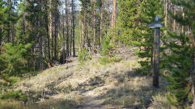
 |
| Red Top Meadows? We'll not be heading in that direction. |
 |
| Goodbye, lovely outhouse! |
 |
| The air strip in the morning. |
Because our dawdling led to us starting our walk around the air strip to get to the trail to the north towards Flossie Lake a little after 8 am. And as we walked around, tried to find the trail, failed to find the trail and just followed the air strip, a plane landed and taxied over to the rangers station off the north south runway.
 |
| I guess this would be plane camping. Like car camping, only with more flying. |
We walked past an airplane and tent where a couple was warming up their engine to take off. We turned up the north south runway to try and intersect the trail and perhaps greet a ranger. And we saw three people, two women and one man, who had just disembarked from the airplane that had just landed.
We smiled at them and waved and they approached us and we came to meet them and talked about our journeys. The women were archaeologists for the forest service and the man was a husband of one of them volunteering to help on the trip. They advised us not to take the north trail to Flossie Lake if we were headed ultimately to Sheepeater Lake, as they were. They had consulted with the local rangers and the trail between Flossie Lake and Fish Lake was reported to be, if not gone, then not maintained well enough to follow.
They also informed us that the woman who usually manned the lookout on top of Sheepeater Mountain was not there, and, in fact, they were planning on staying a night or two at the lookout on her invitation. This disappointed Ambrose, since he had wanted to meet her and talk to her.
The archaeologists were delighted to see us; one of them mentioned that in the years she had been taking trips into the backcountry for her work, we were only the second group of people she had met out there taking a trip for fun. And we had made pretty good time on our legs to get where they had flown that morning. I can see the attraction of flying into somewhere like Chamberlain, to gain easier access to the wild terrain. But I can’t see being able to afford it. And besides, every step we took to get there made the arrival all that much sweeter.
We parted ways after putting on our sunscreen while they prepared for their day’s hike. And then we turned right around and headed to the trail we’d ignored as we were leaving our camp for the morning, the one that led to Red Top Meadows.
 |
| Another outhouse on the east side of the airstrip. |
 |
| Ahem, well, I suppose we shall be going to Red Top Meadows after all. |
If we hadn’t dawdled, then we wouldn’t have met the archaeologists and would have gone to Sheepeater by way of Flossie and might have gotten into a spot of trouble if the trail proved difficult to follow. The morning’s events happened as they needed to, even if we did make a detour of about a mile.
And then we discovered that the trail to Red Top led directly to a nice bend of the Chamberlain Creek that would have been a lot nicer to fill our water from than the backtrack that I did. Now we know.
We had maps that showed our new route, and of course the GPS, so we weren’t worried about changing our route mid-trip, especially because they told us that this route was only 9 miles as opposed to the 10 of our original plan. And there would be less rolling terrain this way. We’d start out following Chamberlain Creek, roughly, and then enter Red Top Meadows before turning up a canyon to Fish Lake and then climbing up to Sheepeater Lake. Easy!
 |
| A nice flat section to start the day. |
Well, the first part was pretty easy. We walked through short pines and taller aspens. The sound of water faded as the creek curled away. The archaeology party passed us in a particularly leafy section, taking me by surprise when they appeared. I gasped, rather than shrieking, but it was a close thing. I figured we wouldn’t be seeing them again at the pace they were going.
 |
| Easy not to notice company when the trail bends and the trees are thick. |
But it wasn’t too long before we did run into them again, hidden in the shade of some conveniently tall trees and snacking on apples, I think. I thought apples were a rather decadent thing to be taking backpacking, but something that made sense if you were going to fly in.
We went ahead of them and then we started to see signs of a bear having been on the trail. Not the piles of old scat we’d seen on the second day, but prints in the dry dust of the trail that couldn’t be more than a day old, maybe even only a few hours old.
 |
| The trail meandered closer to the creek. |
 |
| That's a bear print. Hey, bear! |
We shouted a lot of “hey bears” and walked with caution. When we were looking for a nice shady spot to take a break, we also tried to pick a spot where we couldn’t be snuck up on by a bear. And, on that break, we also kept an eye out for our fellow travelers, but we didn’t see them to warn them about the bear. Nor did we see the bear.
It felt like we were making good time. I knew we had a stream crossing to make before we crossed into the meadows. There was a four way junction on the map that I’d been warned was actually a three way junction now. Turns out there was no junction at all.
We reached the crossing. It was deep enough to be boots off but also crisscrossed with a lot of fallen trees. Ambrose opted to go boots off, and I headed upstream a bit through tall grasses to get to a log crossing that I felt comfortable taking. We both got across in about the same amount of time, but I was considerably dryer.
 |
| Lots of tree bridges to choose from. |
 |
| Ambrose going boots off, taken from the middle of my tree bridge. |
I walked past where Ambrose was getting his boots back on to a nice shady spot under a large, old tree. It smelled a bit like bear, or at least like animal, the scent carried on the breeze, but I figured if we were noisy nothing would bother us. And I wanted to have lunch while we were near water. So I got lunch going while Ambrose did his things. When I went to get water I saw our fellow travelers reach the stream. They hiked past us for the last time that day after Ambrose warned them about the bear sign.
And then Ambrose got to have some privacy at the stream for a little wash up while I filtered water for lunch and mushed up the dehydrated desserts (mocha mousse pie again) in their individual baggies and also read. Reading is relaxing for me, and I like to do it even when I’m out in the wilderness. Our lunch may have run a little long as Ambrose tried using his sealant on the water bags, which then needed to dry.
When we got moving again, I hiked ahead, because there would be another stream crossing making for a natural stopping point not too far ahead. It only took me about 20 minutes of walking through sparse forest to reach the next stream crossing. I liked the feel of the area; it was cool and peaceful and I couldn’t smell the animal musk anymore.
The crossing itself was too deep for boots on, and though there was a single log that looked like a possibility, it only crossed to an island and another crossing log was not in evidence (though a large fish was for a moment before I startled it). I sat on a large log in the shade and took my boots and socks off. Ambrose walked up as I was putting my crossing shoes on.
 |
| I saw water through the trees... |
 |
| And then came upon the crossing. |
He chose to cross with his boots on, because his crossing shoes had changed into camp shoes and he didn’t want them to get wet. He did take out his insoles, which helps with drying afterwards, but I’m not sure why he didn’t just cross the crystal clear water with the lovely sandy bottom with his bare feet.
After the crossing, the terrain stayed fairly flat, but we now walked through sunny, dry old burn areas. Young pines weren’t quite tall enough to offer significant shade, and the dead trees lacked the foliage to cool me when I paused in their narrow shadows.
I hiked ahead again. Even with the hint of bear on the wind earlier, we felt comfortable moving at our separate paces on this part of the trail. I enjoyed stretching my legs, though I wasn’t going as fast as I did on my solo. I didn’t need to, and I didn’t want to get too far ahead of Ambrose. On our map, there was a spot marked as a campsite, right near a stream. We agreed to meet there.
I had high hopes for seeing something resembling a campsite near this stream. Sure, the map is old, but where there’s water, there tends to be campsites. Unfortunately, another requirement for camping sites is clear ground. The ground near the stream, when I reached it, had no clear space large enough for a tent to be pitched. Too many fallen logs. There were some grassy sections, but the grass was so tall, there was no telling if the ground beneath was flat enough - or dry enough - to camp on.
 |
| Typical representation of the off trail terrain - plenty of wood, not so much open space. |
 |
| The water that used to be near a campsite. |
 |
| Tall grass that could conceal many mysteries. |
I settled down on a log to read and wait for Ambrose to catch up. According to the map, our next landmark was the trail junction where we would turn up to Fish Lake, and it shouldn’t be far. Once he arrived, I thought we’d stop for a while, but he wanted to keep going and so I had to pack up and hurry after him. Of course, I caught him quickly, but I stuck with him since we were pretty close to the junction.
We took a break at the junction. Ambrose struck off trail to find a bit of shade to snack in while I went off trail to find a place to dig a hole. He was finished with his break before I was, and started heading up the switchbacks while I finished a snack.
We had had an easy time of it to this point of the day. Very little uphill, just a bit of rolling terrain. The trail was about to start going radical on us, and it began with a series of switchbacks moving us up to the canyon carved by Fish Creek. After I passed Ambrose, I tried to stay within a couple switchbacks of him, within sight. It was nice to take the breaks, but I also got to make sure that he was doing okay.
 |
| Trail junction! |
 |
| Time to go to Fish Lake - and gain 1100 vertical feet in the process. |
 |
| Looking back down from the first few switchbacks. |
I was doing that because I love him, of course, and like spending time with him. But I had another reason, on this particular trip, for keeping a close eye on my husband. He had spent the days before our trip running over and over the list of things he needed to bring on this backpacking trip. He managed to remember a few things that he almost forgot, but he also managed to forget some very important items.
He forgot his prescription high blood pressure medication.
I first learned this on the morning of our second day, when I asked him if he took his morning pills. And I did not yell. I did not go apeshit. I feel that I deserve a gigantic pat on the back for taking the news quite calmly. After all, there was nothing we could do to change it at that point. I did ask that he refrain from using any Benedryl, because we know that affects his blood pressure, but other than that I practiced acceptance.
And I also kept a closer than usual eye on how he was doing on the trip - for the most part.
We gained elevation quickly, and though I could hear the creek tumbling down, I couldn’t see it very often. The water was covered by plant life and tumbled trees. The wind blew harder as we climbed, and the sun played hide and seek with the clouds. I enjoyed both of those because the climbing was hot work.
 |
| I like the black and white striations of this kind of rock. |
 |
| Looking back down from a higher vantage point. |
 |
| Waiting for Ambrose gave me opportunities to get a few wildlife photos. |
 |
| The water below was audible, but not very visible. |
According to the map, at some point the trail would stop switchbacking and climb mostly straight up the canyon to Fish Lake. When the trail did straighten out, about two switchbacks after I thought it would, I hiked a bit farther ahead of Ambrose. The trail was brushy enough that I couldn’t see him from less than 20 feet away, so I went back to waiting for him when the timer told me it was time to stop.
We could see, in the distance, the lookout tower on top of Sheepeater Mountain. It gave me a sense of being close, even though we really weren’t that close. When we saw it, we still had several hours of hiking to go before we would get to the lake. And of course I was constantly recalculating how much farther we must have to go, but since we weren’t on the guidebook route, I wasn’t able to be as exact.
 |
| The lookout from afar. |
 |
| Yes, I had to wait for Ambrose to catch up and then give him the camera, but I really was waiting for him like this. It was quite a comfortable log. |
I walked a little bit past the alarm in search of water. The map showed a little stream coming down across the trail, but I’ve learned that those are far from reliable. In this case, however, I found a beautiful little stream, trickling musically over stones, situated right near some nice big sitting logs. I took my boots and socks off to let my feet dry out a bit after I filled my water bags from the stream. While I waited for Ambrose to arrive I refilled my water bladder.
 |
| Water in the brush. |
 |
| More water, a little less brush. |
We both poured some water over our heads at that stop, and one, perhaps both, of us shrieked a bit at the feeling of the icy cold water. The sun had stopped hiding behind the clouds at this point and the hike was hot.
I moved ahead again and ran into more water - a good sign we were getting close to a large body of water, say, Fish Lake. The trail was also built up nicely over areas that would be quite damp earlier in the season, but were dusty now. I reached a larger stream around where I expected to cross the outlet from Fish Lake and settled in to wait for Ambrose again. I managed not to notice that there was a burned sign right across the water labeling it clearly enough as Fish Creek. After he caught up, I walked behind him. There would be a junction coming up quickly, one direction leading to Fish Lake and one to Sheepeater, so there was no point in my rushing ahead.
 |
| A little land bridge over what is most likely bog in early summer. |
 |
| Ambrose crossing Fish Creek. |
 |
| I can't be blamed for missing this sign, right? |
And it wasn’t too long before we could see Fish Lake through the trees on our right, nestled in a bowl of land and gleaming in the late afternoon light. At the trail junction, we took a left, heading uphill towards Sheepeater.
 |
| Fish Lake! |
Now, I knew that the section between Fish Lake and Sheepeater Lake was going to be a climb; it was about 500 feet up in less than a half mile. So I expected the switchbacks, but I didn’t expect how much the trail seemed to meander. Although, that impression was probably influenced by the fact that the ridge above us blocked out the setting sun and I felt the pressure of the coming dusk with every step I took.
 |
| Trail junction - to the right is Fish Lake, to the left is Sheepeater. |
 |
| I tried to imagine what it would look like if those trees were all still alive. The view simply wouldn't be the same. |
I rushed ahead and waited, moving on as soon as Ambrose was back in sight, keeping his goal posts well in front of him. All told, it took us an hour to get to Sheepeater Lake, passing yet another trail junction that only existed on paper. And here, we planned on finding a campsite. We thought it would be easy to find one, because it was a lake zone that didn’t allow camping too close to the water. Surely, we thought, there would be a clear place to settle down.
 |
| I sat on this log to wait for Ambrose to catch up on the switchbacks up to Sheepeater Lake - but I managed to avoid sitting on the nail. |
 |
| Looking back down, I could no longer see Fish Lake. |
 |
| According to the map, this was the outlet for Sheepeater Lake. I was a little worried to find it so completely dry. |
 |
| That sign means the lake is right there! |
But I looked to the right and the left and saw no signs of any such campsite. The trail began to climb again and I decided to abandon it in favor of what were probably game trails towards the water. And then we began our great wandering.
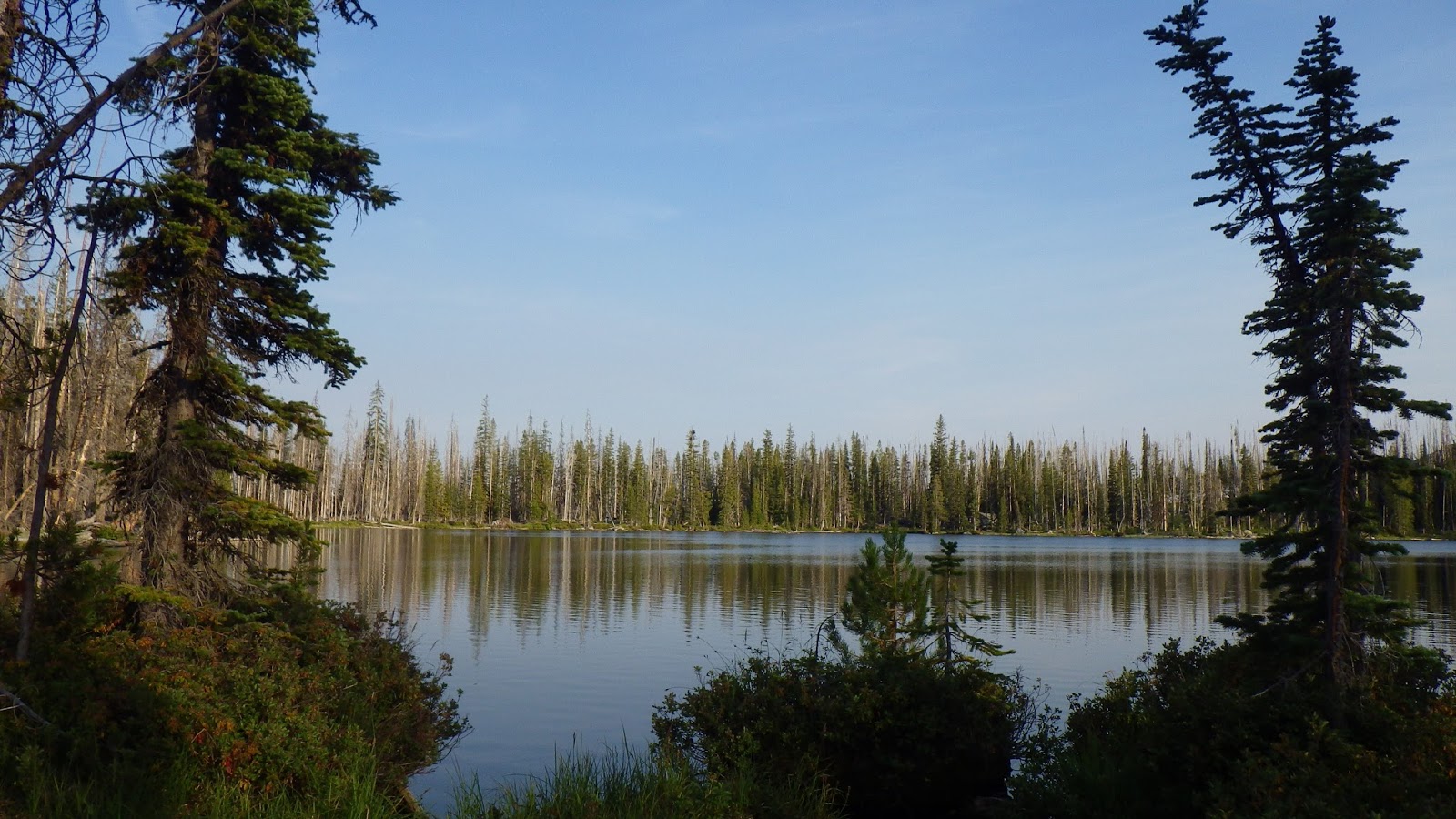
 |
| Lake! We made it to Sheepeater Lake! |
 |
| And the sun is setting. The sun is already behind Sheepeater Mountain and daylight is fading. |
Both of us needed to eat. It was after 7 pm and, despite our resolution to eat dinner around 5, we hadn’t eaten dinner yet. We explored the land near the lakeshore, but not too near the lakeshore. We found bogs, logs and signs of bear. We found piles of rocks that jumbled the ground out of flatness. We found places that might have worked, if only they weren’t so damp, too close to the water, not quite flat enough.
 |
| This is not a campsite. |
 |
| Those are chunks of fur, I think, but from what I don't know. |
After much wandering, I found a large, dry meadow. The ground was lumpy, because it had been mud not too long ago, but I figured it would do. It had to do.
 |
| Well, it's dry and flat-ish... |
But Ambrose was not ready to settle. I lead him to the place and he wandered more and found what would become our campsite. There was evidence that it had been used before, a broken up fire ring and a pile of rocks that might have been an attempt at a wall. We dropped packs, got water together because we were both so out of it, and then Ambrose got to cooking dinner while I handled the tent.
 |
| Official campsite? Maybe not, but it was far enough from the water and had flat spaces enough to pitch the tent. |
Before I could pitch it, I had to clear a bunch of pinecones from the ground. It was not a happy time exactly, squatting and pulling up pinecones that were sometimes submerged in dried mud and other times just sharp on my hands. I felt lightheaded with hunger, but I pushed through it and got the tent pitched. We ate dinner in the tent, because the mosquitoes were out.
Again, I wrote my fiction words by headlamp and read a little bit while Ambrose fell asleep with an ease that I can only envy.


No comments:
Post a Comment