Blogger is being difficult. I had a bunch of pictures uploaded and ready for captioning for the Tour de Meadows Day 4 post, but all the jpgs are breaking and I can't re-upload and even the jpgs on the page that I'm using to edit this post is broken, so I'm totally blaming Blogger for these issues. I don't want to post that write up without the full slate of pictures, so here's an update on my goals for the year, and the Spartan Plan.
The first goal was completed back at the end of the 2018 CrossFit Open. That goal was to complete 2 or more workouts in the Open as prescribed (Rx). I completed all 5 Open workouts Rx.
The second goal has also been achieved, as I had a witnessed set of 12 kipping pull-ups back in June and have since done a set of 12 linked in a workout (where I did 21 in under a minute, woo!).
The third goal was to hike the section of the Idaho Centennial Trail that would link my prior two sections. That one is also done, and plus, because I also hiked as far as I could into the Frank Church and still get picked up by my husband (with a hefty dose of luck considering he had to break an evacuation to get to me).
And the fourth goal is complete as well, because I finished the Boise Spartan Sprint in June. Gosh, I didn't leave myself much more to do this year?
Well, I do have an unofficial goal of making Commitment Crew at Arbor CrossFit every month in 2018. And I'm 10 for 10 so far, with 2 months to go. So I'm still reaching for that goal at least.
And after the Spartan Race, I came up with a plan to do better next year. Because doing 210 out of a possible 240 penalty burpees might technically count as finishing, but I want to do better.
That plan was to get some personal training in October in order to start doing extra workouts specific to what I need to improve in the Spartan Race. That's mostly the upper body stuff that involves holding my own weight up. And I have done that. I've already completed a week of my new training routine and I'm sore all over.
The next step on that plan is to sign up for the race, but that will wait for January when they have the New Year's sale. So I'm on track for my Spartan Plan.
I guess another goal would be to stick with my personalized exercise plan and make sure to get out to the archery range with a spear at least once a month. And to haunt playgrounds every now and then to practice my monkey bars!
Wednesday, October 31, 2018
Wednesday, October 24, 2018
Frank Church Tour de Meadows 2018 Day 3
We had a bit of a disagreement as to how the day should go this morning. Well, the disagreement started the prior night, but continued on to the morning. Both Ambrose and I wanted to go, as planned, to Lower Ramey Meadows. Bill thought that we should heed the word of the horsepacker and go by way of Upper Ramey Meadows instead, since the trail to Lower was supposed to be no longer maintained.
But we all agreed that we should go and check out Rock Rabbit Point, as long as the trail wasn't too horrendous to get there.
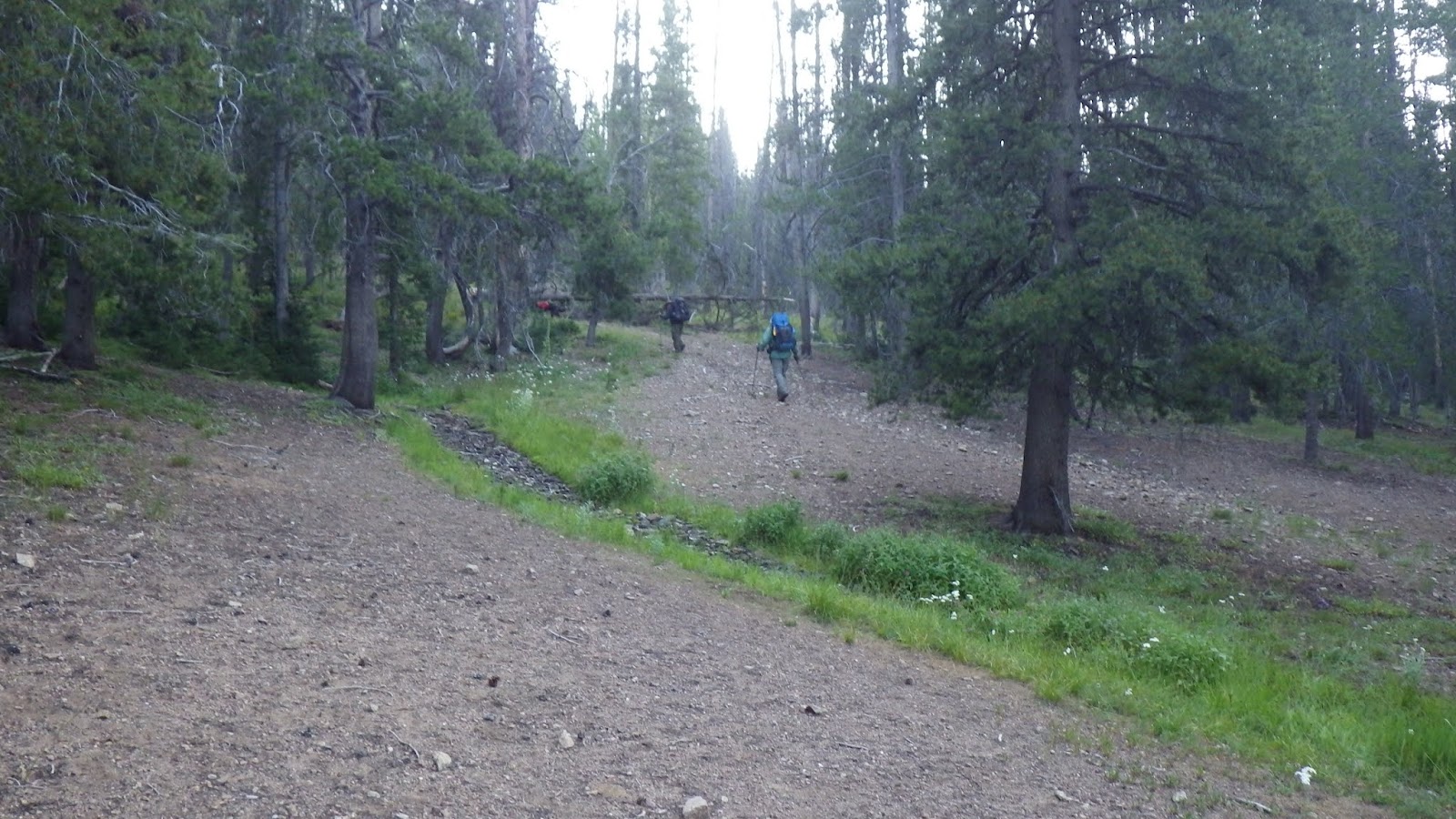
So we set out, taking the trail the horsepacker had taken to exit. It rejoined the main trail at a familiar junction. Last year, I thought this trail was the start of the old one going down to Beaver Creek, but nope, it leads to the spring. A very steep trail, so I got warm pretty quick.
Then we had a nice morning ridge walk, through some recovering burned areas and some places that still had trees to shade us from the rising sun's rays. This part of the trail was familiar to me, so I was prepared when the ridge had a few climbs, and when the trail went over to the east side of the ridge, I knew to start looking for a right angle turn.
Bill and I were walking ahead of Ambrose and reached the sign for Lower Ramey Meadows. I, of course, took the sign to be an indication that said trail was still there. But Bill still had his doubts. We rested until Ambrose arrived and then there was some dithering about whether we should go on. I insisted that we all wanted to check out Rock Rabbit, so let's go. And I walked off. I was feeling a bit snitty.
And the trail got a bit rough, with lots of deadfall, and I waited for everyone to catch up and asked if they wanted to turn back. We all agreed to press on at least to the point.
I am so, so glad that we did.
I didn't know what to expect at Rock Rabbit Point, but I was not at all expecting a cabin. Not recently lived in, I'd say, with the broken window glass on the floor and some floorboards missing, but it's standing and has a door. There's also an old lookout tower that is barely standing and large piles of rocks.
No rabbits that I saw.
After gawking at the cabin and its environs, we kept going for a bit. The trail started easy and then got ridiculous with the amount of blowdown. For some reason, we all persisted past the worst of the blowdowns, and then I asked if everyone was comfortable going on. Bill volunteered that he was not, because Mike has a harder time navigating through rough trail.
But now Ambrose was set on going on. So we compromised. Bill would head back to the main trail with Mike and they would go through Upper Ramey Meadows and spend the night somewhere along there. We would meet up in the morning where the trail from Lower Ramey met up with the trail from Upper Ramey and then continue together.
I was quite satisfied with this solution, since Ambrose wasn't sure about making the extra distance going around to Upper Ramey would entail. And it meant that I got to have a bit of adventure alone with my husband.
Maybe a bit more than a bit of adventure...
The trail was decent for a while. And then we came upon a recently burned area. Recently enough that the ground was black ash, with very few sprouts of green growth. Trees were blackened and many had fallen. Blazes were not visible and neither was the trail. But we knew the direction we had to take. We persevered and regained the trail.
And again, it was good for a while. Some blowdowns, but nothing to write home about. We got pretty far, far enough to be thoroughly committed to our route before the trail completely disappeared.
We did not panic. We used our tools. First, map and compass, but the heading we got didn't feel right. So we pulled out the GPS and used it to navigate in the general direction of Lower Ramey Meadows. We weren't going to find the trail on this particular GPS model, but we could find the meadow. Not a direct route, because we detoured around a really thick section of young trees. And we actually ended up a bit too high in the wrong direction and had to come down into a kind of burnt bog.
And in this bog, in August, we stumbled upon a treasure hoard of morel mushrooms.
We have hunted for these little suckers in the "right" season (early spring), in the "right" places and never found more than a single mushroom at a time. And now, in the completely wrong season, in the middle of nowhere, we found this bounty. But we did forget to tag it on the GPS...
I harvested several mushrooms for Ambrose to carry and then we hiked on, soon reaching the meadow. It was such a wide, open space of green. Yellow also, because it was later in the season, but the colors were all fresh and right. Two cranes were startled by our arrival and flew off, honking at us in protest. We walked across the meadow, taking care not to step into a hidden stream, and came to rest under the shade of a couple of large pine trees.
We could have camped there. It was lovely. But I like to be prepared, and that meant finding the trail again before settling in for the night. We stumbled around a bit before I figured out a good tactic. Follow the water - the trail crossed Big Ramey Creek, and the GPS could show us that creek. So we just had to follow it up until we hit the trail. Easy.
The trail, however, wasn't the first indication that we were in the right place. No, that was Mike, running along and barking greeting on the far side of the creek.
Bill had decided to continue past Upper Ramey Meadows to the junction, and then explored and decided to cross the creek because he found a sign for Lower Ramey Meadows - and that's where he was camped.
Ambrose and I set up camp not too far from Bill and we got to the business of chores and relaxing and settling down for the evening. At one point, I thought I might need to dig a hole, so I took a walk. I found a little mini-meadow and walked into it to find a good spot. Instead, I found a grouse, just sitting on the ground, absolutely still. I left, because I didn't want to frighten it. And I didn't need to dig a hole anyway.
It was a pretty good place to camp, fairly flat and forested. But it was nothing like the meadow. There wasn't even a view of the meadow. And that was a bit disappointing.
 |
| Mike's ready to go and so is Ambrose. |
 |
| A bit of a climb to start the day. |
 |
| Ambrose in the lead - that didn't last long. |
 |
| Mike sometimes lets me lead. |
 |
| Regrowth after the burn. |
 |
| This part wasn't burned at all. |
 |
| Getting close to the junction. |
 |
| Ahhhhh! To the left, familiar, to the right, unknown. |
 |
| That's no rabbit! |
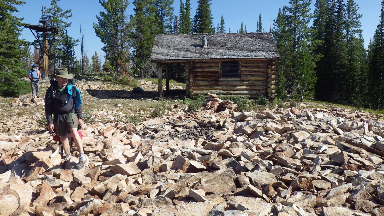 |
| Lots of rocks though. And a cabin. Bill is in the foreground and Ambrose is farther back. Between them is the remnant of a fire watch tower. |
 |
| Oh sure, this trail's just fine. |
 |
| And check out these views! |
 |
| Well, okay, trail's a bit toasted here, but we're fine. |
 |
| See, back to trail. No problem. |
 |
| Um... also no trail. |
 |
| Yeah, this isn't trail either. |
 |
| Nope. Nope. Nope. |
 |
| We ate lunch somewhere around here. But it wasn't a good place to hike. |
 |
| Up here was easier, but also easier to get off track. |
 |
| The meadow is out there. Straight ahead? |
 |
| Morels! |
 |
| Lower Ramey Meadows. This hardly captures a fraction of how gorgeous this place is. |
 |
| Angry birds. |
 |
| Ambrose in the meadow. |
 |
| These grasses were chest high on me. |
 |
| And they concealed creeks, and creek beds, that would drop you down a couple feet if you stepped in them. |
 |
| This sign proclaims Lower Ramey Meadows, but it's nowhere near a view of the real thing. |
Wednesday, October 17, 2018
Frank Church Tour de Meadows 2018 Day 2
We got up early, but not super early, in order to make the most of the time of day before the sun rose over the ridge and made us all overheat. Where Beaver Creek met Big Creek, there were still a ton of logs, more even than last year. They practically bridge Big Creek, though I don't think I'd care to try crossing on that shifting pile.
After the bridge over Beaver Creek, I hiked ahead of Ambrose, Bill and Mike. It was good to get some "alone" time on the trail. I kept up a good pace to try and stay warm in the early morning chill. I got a little paranoid about possibly missing the trail intersection, but it came up in due time and I dumped my pack on the trail to take a break and wait for the men to catch up.
Bill wanted to spend some time taking care of Mike before starting up, so Ambrose and I got started before him. I quickly got ahead of Ambrose, but he kept up a good, steady pace. I could tell when the trail switchbacked around and gave me a view of him, and, eventually, Bill and Mike, making their ways up behind me.
I caught up to the sun for a few brief minutes before the trail took me back in the shadow of a ridge. The trail here was as I remembered it from last year - long, switchbacky to the point of annoyance and STEEP!
But I made really good time since I wasn't waiting on anyone to catch up. We had agreed to meet where the water crossed the trail above the old Estep cabin, and that was where I would stop.
Well, actually, I stopped just below Estep to try and take care of some business (without success). And I confused Bill by doing so, because he was close behind and despite my earlier verbal instructions, followed me off the trail to where I was digging a hole.
Bill and Mike and I went up to the water crossing and settled in to wait for Ambrose. I was trying to soak up some sunshine, so I went back down the trail a bit instead of staying right by the water.
Ambrose arrived in a time much improved from last year's. Part of that is the familiarity of the trail, but part is the hard work he put in to make it to Shi Shi Beach on the coast. We ate lunch - oh, and I forgot to mention, it somehow slipped my mind, that I forgot to pack our sporks.
Now, in my defense, Ambrose took out the cook kit and handed it to me, and I didn't realize that the cook kit was stored with EVERYTHING in it EXCEPT the sporks. But I should have checked the kit before checking sporks off the list, I'll own that. So, we had one spork between us, since I had brought one with which to eat my Reese's Spread. I thought Ambrose had brought one, too, but he had decided against bringing any spread at the last minute. So. One spork. Two hungry people.
I made one lunch, ate it, then made the second lunch and Ambrose ate that. Oh, and these were really good lunches. Trailtopia Cheesecake Chocolate Raspberry is incredible. We like having a dessert for a meal, because it's a sweet treat and easy to eat, but most desserts are small enough that we need to supplement them for a full meal's worth of calories. Not this one. This one is 2 servings of 343 calories each, or a full lunch for one hungry backpacker at 686 calories. And most cheesecake backpacking desserts are really more like puddings - tasty puddings, but gloopy. Trailtopia's cheesecake gets more fluffy, and I love the freeze dried raspberries and chocolate chips that break up the sweetness of the cheese with a bit of sour and a bit of chocolate. I love this lunch.
After lunch, we had some more climbing to do, and some more switchbacks, but they weren't quite as irritating to me. I knew I was getting closer to the top. This time, Bill struck off ahead. I somewhat kept Ambrose within a reasonable distance, just because I wanted to share things with him. Like the fact that the huge tree that gave us issues last year had been cleared. And where the sneaky switchback was. And then an official break when I caught up to Bill and Mike.
Poor Mike was collecting tons of little burs in his fur. Bill got some of them out while we waited for Ambrose, but there wasn't much point in finishing until we were at camp.
Then Bill and Mike went ahead to the top of the ridge, and I pulled away from Ambrose as I made my way up. Bill and I each found patches of shade at the ridge top trail junction while we waited for Ambrose.
Ambrose arrived, we took a break, and then hiked along the ridge for a bit. And then it was time to find out if we were right about the trail junction we saw last year.
Ambrose and I were sure taking a left at this unmarked junction would take us to water and, most likely, good camping. But we hadn't checked last year, we couldn't confirm with absolute certainty that we were going the right way. I got even more nervous as we walked down the trail, because I thought it would be short. It wasn't nearly as short as I thought it would be, though the descent was nice and mellow. And then, I saw through the trees a structure.
Yes. A freakin' cabin out in the middle of the wilderness. Oh, and a spring, too.
But I was excited about the cabin. It was collapsed, but not completely. There were places inside still sheltered from the elements, and you could look around inside it (though I wouldn't suggest or condone actually entering it).
We found decent places to pitch our tents and had a nice long afternoon to hang out.
A horsepacker came up on us while we were still settling in. Bill went over and talked to him because Mike was making a ruckus about the horses. According to the horsepacker, the trail to Lower Ramey Meadows was no longer maintained, which would put a crimp in our plans. But that was a problem for future Jeanne.
I relaxed and started carving a wooden spoon to try and make up for forgetting to pack the sporks. Everyone kind of did their own thing, including the normal camp chores of putting up tents and getting water and drinking water and then getting more water. I explored the area a bit; it seemed to have gotten a good deal of use at some point. There was even an old power hook up near the cabin. I have no idea how they got power out there.
Overall, it was a very good day, and we wouldn't have to get up quite so early the next morning.
 |
| Ambrose is ready to go. |
 |
| So is Mike. |
 |
| Sure, the logs look like a bridge, but I wouldn't cross on them. |
 |
| A good flow of water in Beaver Creek. |
 |
| Lovely little flowers. |
 |
| That sun is so lazy, it hasn't climbed the ridgeline yet. |
 |
| Made it to the junction! Didn't miss the trail! |
 |
| There are several places on the way up to the ridge where you can clearly see the trail ahead. |
 |
| And then you can see the trail behind - including Ambrose (blue speck). |
 |
| I found the sun! |
 |
| And then I lost it again. |
 |
| But it came back! |
 |
| And then disappeared again. |
 |
| But then I found this little guy. Almost as good as sun. |
 |
| The stove from Estep is still here, but in a slightly different location from last year. |
 |
| There's still water crossing the trail, phew! |
 |
| Heading up to the ridge. |
 |
| Not a bad reward for all that sweating. |
 |
| Bill at the ridgeline trail junction. |
 |
| A daddy-long-legs found my leg. |
 |
| Bill and Mike at the spring trail junction. We went left! |
 |
| And then we found a cabin! |
 |
| I find this kind of thing incredibly neat. |
 |
| Oh yes, there was also a spring with flowing water. |
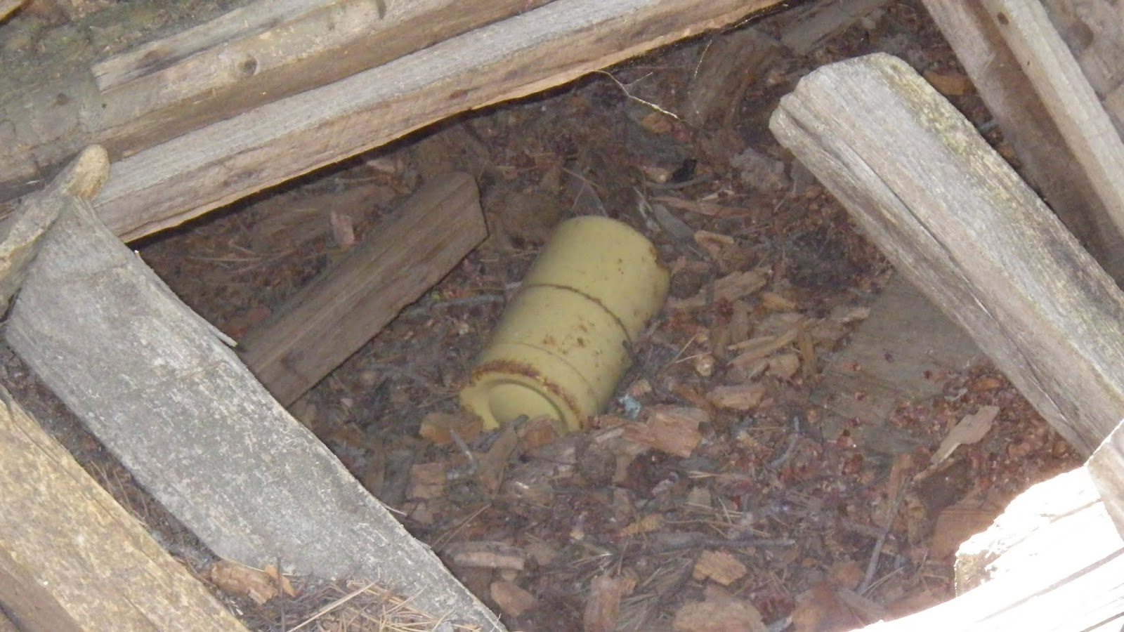 |
| I'm pretty sure that's an old fuel canister inside the cabin. |
 |
| I had my socks on my trekking poles to dry out and it turns out that butterflies like gross stuff. |
 |
| We ended up pitching tents pretty close, because there weren't actually a lot of flat, non-rocky surfaces near the cabin. |
Subscribe to:
Posts (Atom)